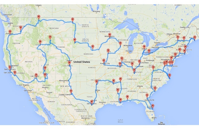
Have you ever wondered what the best cross country road trip map looks like? When it comes to travel distances, rare sights, destination amenities and unique highlights, we feel the Michigan State University study nails the best road trip. The University’s own Randy Olson crafted a road trip map spanning across 50 stops. (Also, when Randy goes on an epic road trip, he brings plenty of trip essentials.)
Use eTags© to Quickly Complete Your DMV Service. Renewals, Title Transfers and More, All Online!

.
How the Map Was Made
Randy optimized the route with a slew of data inputs. To get around typical travel challenges, he used Google Maps API. Then, he calculated the distances between 50 predetermined landmarks. The result was a power-packed 2,500 individual routes.
So, how was this possible? Bloggers and other map-makers think it’d take a computer decades to account for the map’s every twist and turn throughout the continental drive. Dubbed the “Where’s Waldo” solution, Randy’s algorithmic answer solves a few problems.
Rather than exhaustively looking at a number of solutions, his solution begins with a mere handful of solutions. These solutions are applied to other problems, constantly using slightly different approaches to normal issues. Eventually, the solutions get better and better.
All About the Fitness Function
Randy’s road map algorithm used something called a “fitness function” which calculates the shortest distances between different waypoints. The result is a pretty slim-fit road trip map.
So, how long is the journey through the supposed best cross country road trip map? Well, it’s long. It takes about two to three months to complete. All in all, you’ll be driving for about 9.33 days—you just won’t drive it straight.
Why Not Another Map?
We won’t lie: There are other maps out there. This map sticks out, mostly, because of its astounding ease-of-use. You can enter the route anywhere, as long as you’re following the map. Once you’ve entered the circuit, you need only follow the path. You’ll always be driving the best route, as long as you’re sticking to the destination-centric parts of the road.
A lot of the map’s destinations are situated alongside other great tourist sites. So, you can pack multiple trips into a single vacation’s stretch. If you don’t want to complete the national circuit, simply, use the route for a stretch of time. The map was made to include national natural landmarks, national parks, national historic sites and national monuments. It needs to be taken by car, and it can’t, under any circumstance, leave the United States perimeters.
Can You Take Up the Epic Itinerary?
The map is a huge mix of inner-city hotspots, exploration destinations, beautiful natural landscapes and must-see historical sites. If you have it in you, take up the trop. Minimize any time spent driving and maximize your time enjoying the landmarks.
If you ever get the chance, check out the map’s awesome rundown. A lot of other maps exist, but they fail in computing the best-possible road trip distances.
There might eventually be a better road trip itinerary. That said, this map hits most of America’s must-see attractions. You might not see many city streets, skylines, or popular shopping destinations, but who likes traffic? America is a beautiful country and its’ natural formations don’t get enough credit.
If you’re planning the best road trip ever, you should focus on the scenery (and of course the safety). Don’t forget to stock up on plenty of road trip essentials, we found the best selection here.


20 comments
The interactive tool doesn’t work for me still. I would love to use this and modify it for my trip with my husband. It’s our retirement trip…3 months of just relaxing and seeing the beauty of our country.
our doesn’t work, but try this site that has apps and interactive maps for roadtrips
https://www.themandagies.com/10-road-trip-planner-tools-apps/
Hi,
The interactive does not load for me on any browser or on my phone. Any way to get it to work? Thanks.
We apologize for the inconvenience, we’re looking into it.
The interactive map will not load for me. Any recommendations on how to get that to load?
Hello Chelsea. Here’s the link. Thank you.
Brian here, The article states travel by car. We are planning our trip in a C class RV. My question is are there any height clearance issues with taller vehicles on this great route?
Hello Brian. It appears that there isn’t any relevant restriction on the type of vehicle you are using to make a trip across the country. Make sure your vehicle is optimal conditions though. You may also ask a mechanic about your intentions to make a long distance trip with your current vehicle. Good luck.
Is there a list that specifies what each destination in each state is?
Hello Nicole. Here’s a list of key areas to visit:
1. Grand Canyon, AZ
2. Bryce Canyon National Park, UT
3. Craters of the Moon National Monument, ID
4. Yellowstone National Park, WY
5. Pikes Peak, CO
6. Carlsbad Caverns National Park, NM
7. The Alamo, TX
8. The Platt Historic District, OK
9. Toltec Mounds, AR
10. Elvis Presley’s Graceland, TN
11. Vicksburg National Military Park, MS
12. French Quarter, New Orleans, LA
13. USS Alabama, AL
14. Cape Canaveral Air Force Station, FL
15. Okefenokee Swamp Park, GA
16. Fort Sumter National Monument, SC
17. Lost World Caverns, WV
18. Wright Brothers National Memorial Visitor Center, NC
19. Mount Vernon, VA
20. White House, Washington, DC
21. Colonial Annapolis Historic District, MD
22. New Castle Historic District, Delaware
23. Cape May Historic District, NJ
24. Liberty Bell, PA
25. Statue of Liberty, NY
26. The Mark Twain House & Museum, CT
27. The Breakers, RI
28. USS Constitution, MA
29. Acadia National Park, ME
30. Mount Washington Hotel, NH
31. Shelburne Farms, VT
32. Fox Theater, Detroit, MI
33. Spring Grove Cemetery, OH
34. Mammoth Cave National Park, KY
35. West Baden Springs Hotel, IN
36. Abraham Lincoln’s Home, IL
37. Gateway Arch, MO
38. C. W. Parker Carousel Museum, KS
39. Terrace Hill Governor’s Mansion, IA
40. Taliesin, WI
41. Fort Snelling, MN
42. Ashfall Fossil Bed, NE
43. Mount Rushmore, SD
44. Fort Union Trading Post, ND
45. Glacier National Park, MT
46. Hanford Site, WA
47. Columbia River Highway, OR
48. San Francisco Cable Cars, CA
49. San Andreas Fault, CA
50. Hoover Dam, NV
Is there a list of the 50 recommended stops?
Hello Lynette. It depends on what you want to do or visit. From national parks to city attractions, you could narrow your list down to your interests and create an itinerary.
Is there an alternate link to the map? Tried to open it on Firefox & Safari with no link.
Hello Lexi. We are currently using that link to access the map. Have you considered checking it from your phone?
What is the total mileage for the entire loop?
Hello Heather. That would be a matter of finding out by making a complete loop experiment or measuring miles driven. Many sources suggest that it would take 7000 miles for a complete loop.
How long does this trip take?
It depends on the number of stops you plan on making.
Fantastic that Tennessee was largely left off the map…
Hello Mickie. You could always create your own itinerary.